Friday 25 January 2013

Comox Valley - North

Post #7 - Comox Valley - North

There are 26 posts in this blog, please visit them all.
<<<< See side bar for more

       A Pictorial View of the Comox Valley
                                       
                  The Comox Valley - North 

                               Includes areas to the north and west of the City of Courtenay
 including Mount Washington.
See also
 Beaches and Churches 
________________________________________________________________________

Sunnydale Golf Club

 Sunnydale Golf Club
5291 North island Highway
250 334-3232
Sunnydale Golf Course is just north of the City of Courtenay

 Excerpts from the Sunnydale Golf Society 75th Anniversary Speech. 
A History: The Sunnydale Golf Course
Courtenay Golf Club Ltd. was formed in 1923 and an additional 89 acres of land was purchased on July 18, 1923 this land included the Sandwick course.  Eleven years later Joe Idiens then purchased the course in 1934 and changed the name to "Sunnydale" (named after a place in Sunningdale Berkshire England) ...................
http://www.sunnydalegolf.ca/about.html
 ____________________________________________________


                                             Courtenay 
Fish & Game Protective Association

Located on the shore of  Comox Lake, the Courtenay and District Fish and Game Protective Association continues to be dedicated to wildlife management and conservation.
http://www.courtenayfishandgame.org/


 Sign for Fish & Game Club 
 Fish & Game Club Sign

 Beach area at Fish & Game Club Picnic & Camp Ground

Buy & Sell Sale at Fish & Game Club

 Fall scene from balcony of Fish & Game Club
          __________________________________  


 Dove Creek

Welcome to Dove Creek

 Dove Creek Hall Sign 

  Dove Creek Hall on Burns Road

_________________________________________________
    Grantham 
Grantham Hall Sign 
 Grantham Hall,  6040 Old Island Highway, Merville

Grantham
At one time Grantham had a school and a church
The school was moved to Black Creek to become the original hall.
St. Mary's Church  was moved to Merville, see history under Merville

_______________________________________________


Merville
   (Once known as The Soldiers Settlement)

Merville is an unincorporated community in the Comox Valley between the City of CourtenayMount Washington, Dove Creek, and Black Creek near the east coast of Vancouver Island. It was named by soldiers returning to the Island after fighting in France for Canada in World War I.
The borders are nebulous and often hotly debated by residents,  but clearly include Merville Road, the Merville General Store, and the Merville Community Hall, likely at the northern end................
Information from http://en.wikipedia.org/wiki/Merville,_British_Columbia

________________________


 Merville Store, a place for the local people to have a coffee and pick up their mail

Merville General Store, 6635 Old Island Highland, Merville, BC     

___________________________________ 


 Merville Hall Sign at Road Entrance


 Merville Community Association Hall, Old Island Highway North
_________________________________


 Road Sign on Highway 19

Black Creek

Black Creek is a community on the eastern side of  Vancouver Island, British Columbia. It is approximately 16km north of Courtenay. It is primarily an agricultural hamlet and bedroom community to Courtenay and Campbell River - approximately 20 km to the north.

In the 1950s many Austrian and German immigrants were sponsored by Black Creek Mennonites, and much of the life of the community was conducted in a mixture of German and English well into the 1960s. The conservative and church-oriented community contributed significantly to the musical and academic life of the Comox Valley, especially the high schools.................
http://en.wikipedia.org/wiki/Black_Creek,_British_Columbia#History


 Black Creek Mall, Old Highway 19 now Highway 19A
 Studio of Artist Brian Scott, Old Hwy. 19, Black Creek, BC
Across from the Black Creek Mall

__________________________________________

 Miracle Beach/Black Creek

 Sign at Miracle Beach Mini-Golf
 
Miracle Beach Mini Golf, Ice Cream and Coffee 
8667 Old Island HighwayBlack CreekBC

The 18 hole newly renovated Miracle Beach Mini Golf  is located at 8667 Old Island Highway (Hwy 19A) just north of Hamm Road.  We have a newly re-modeled clubhouse and a large back deck. We serve ice cream and Salt Spring, Fair trade, organic coffee.
http://www.miraclebeachminigolf.ca/  
 ___________________________________

Black Creek Association


The Association was formed in 1958 by a group of local residents, many of whom still reside in the area and remain active in the community. Originally formed as a nonprofit recreation association, the group of volunteers involved initially purchased ten acres of land on Black Creek Road. A playing field was high on the list for the community. In 1961, they purchased the old Grantham School. As the cost of moving the school would be about $500 and since no grants existed then, members of the Association raised the money. To prepare the site, the pioneers of the Association picked rocks, cleared the land - even drove a loaned C-2 Cat “day and night” because it was borrowed only for the weekend! By 1962 the facility was fully functional, complete with heat and bathrooms. Over the years, the baseball field was cleared and the original tennis court was constructed .....................


 Black Creek Hall sign at entrance
Black Creek Hall, Black Creek Road, Black Creek, BC
There is a sports area beside the hall

A Brief History of Black Creek Community Association: For complete history go to the following website:  http://www.bccaonline.ca/history.html                                              

______________________________________________ 
 Halbe Hall sign at driveway entrance  

 Halbe Hall, 8369 N. Island Hwy, Black Creek
Originally called Oyster River School, the name was changed to Black Creek School. It is now Halbe Hall, and is used for craft sales, OAP meetings, and other community functions.
Address: 
Island Highway, Black Creek, BC Canada, v9j 1k8 info from http://www.waymarking.com/waymarks/WM43D8_Black_Creek_School_Black_Creek_BC

__________________________________________________

Saratoga Speedway
 Saratoga Speedway 2380 MacAulay Road, Black Creek, BC
Saratoga Speedway is a complex consisting of a 3/8 mile D shaped paved oval and a 1/16 mile paved dragstrip, located north of Courtenay, British Columbia. Turn one is banked 14 degrees and the other turns are flat.

Historical Note
 The paved oval opened in 1966. The front straight was used for 300' paved drags from 1984 to 1986. The 1/16 mile dragstrip opened in 1997. A paved figure 8 course opened in 2001.
http://www.na-motorsports.com

________________________
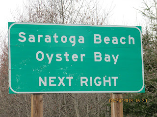
 Road Sign on Highway 19

Oyster River

Oyster River is a small community located between Campbell River, BC (12 km to the north) and Black Creek, BC (100m to the south) mainly along or shortly off of Highway 19A. Located just north of the estuary of the Oyster River,[1] it is home to around 1500 people and a very small commercial sector.

LocationOyster River is named after the river that draws its southerly border with Black Creek. Three bridges cross the river and signify the entrance into Oyster River when traveling north. All thou the northerly border is somewhat ambiguous, the "Driftwood Restaurant," a Chinese-food establishment, is located on the coastal strip of the highway about where most people consider Oyster River to end.

Oyster River is considered to be the northern boundary of the Comox Valley

Oyster River 
Picture taken from bridge crossing on old highway 19

_______________________


Oyster River Mall
Sign for Oyster River Mall

Oyster River Mall
This mall is on the north side of the Oyster River, though not in the Comox Valley I have included it in this blog
A short distance north of this mall is a rest area, Oyster Bay Shoreline Protection Park  and the Driftwood Restaurant. 
   ______________________________________ 


 Road Sign on Highway 19


Mount Washington 

Phone: 250.338.0226
Mailing address:
Tourism Mount Washington
#1 Strathcona Parkway
Mount Washington, B.C. V9J 1L0
British Columbia
Canada

Downtown address:
Unit 205, 841 Cliffe Avenue
Courtenay, B.C
(opposite City Hall)
Toll Free Reservations: 1 877 754 4661
International Reservations: +(1) 250 590 1771

Mount Washington Alpine Resort boasts one of the most spectacular coastal alpine settings in North America. Located in an enviable geographic location, sandwiched between the Pacific Ocean, Strathcona Provincial Park and the Beaufort Mountains to the west and the Georgia Straight to the east Mount Washington Resort is a family friendly destination that has summer and winter facilities and activities for adventurers and outdoor enthusiasts of all ages and abilities. 
Mt. Washington Alpine Resort (skiing, snow boarding, snow tubing, snowshoeing, bungy trampoline, disc golf, mountain biking, Alpine trails etc.  

Bungy Trampoline
Safely harnessed in, you can explore the thrills of extreme bouncing at Mt. Washington Alpine Resort! This is trampoline fun with a twist. Or a flip.
Phone Number: 250-338-1386
Website:  
Toll Free: 1-888-833-1515


       The above pictures are from the Mount Washington Alpine Activities web site


                                  http://www.mountwashington.ca/winter/winter-activities.html

                                                               _____________________________________


 Mountain Biking at Mount Washington


 Photo taken from chair lift a few years ago
The Comox Valley is blessed with a plethora of multiuse and Mountain Biking trails, with a diverse network of trails ranging from easy forest roads to slick rock downhill and classic gnarly single track. Many of the trails revolve around the Puntledge River and Comox Lake in the Courtenay area. Mountain bikers who like their ascents easy, and their descents long and sweet, can't get it any easier or sweeter than catching the Blue chairlift up Mount Washington and riding down. The mountain biking season here generally begins by July 1 and extends through August. At the end of the day you can take a long time making your descent back into the Comox Valley.
http://www.vancouverisland.com/regions/towns/index.asp?townID=236&more=true

                                                __________________________


  The next post is


or
  Click the posts under Categories for more views of our valley
<<<<<<<<<<<<<<<<<<

                                                __________________________

This page is copyrighted, please contact the author at rhodaross@telus.net for permission to use.


1 comment:

  1. contact information - my new e-mail is rhodapross@shaw.ca

    ReplyDelete